C175/08
18 June 2008
One hundred years after Alfred Canning surveyed the Canning Stock Route with the help of the stars, a compass, a theodolite and a chain, Curtin University of Technology’s Spatial Science students will be challenged to reveal Canning’s surveying methods on an industry sponsored trek along the historic stock route.
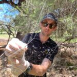
In an effort to upgrade the state’s geodetic network, the students hope to find and resurvey century old survey marks, left by Canning in 1907 in difficult terrain that has been degraded by grazing, burning and human movement.
Assisted by representatives from the Martu and Birriliburu people as well as Curtin teaching staff and professional surveyors, the team will register accurate GPS coordinates for each of the found survey marks, and will seek out unregistered marks in the vicinity of the first mark.
Beginning at Well 22 at the Talawana Track intersection, the team will travel south along the track to Wiluna. The group of 18 commence their 16 day journey on 3 July 2008.
Landgate, the Statutory Authority responsible for Western Australia’s land and property information is one of the industry sponsors for the expedition. The team will be responsible for upgrading Landgate’s geodetic network which has implications, not just for adjoining pastoral leases but for native title claimants and mining tenements as these are all linked to the marks. The students will be upgrading the Benchmarks to Standard Survey Marks.
Mr Joe Mahoney, Project Leader, believes the project is not only significant for pastoral leases and native title claimants, but has important historical implications.
“Canning successfully surveyed the route over a three-year period and was re-surveyed in the 1930s by Payne and Allsop. The expedition will be re-tracing both surveys,” Mr Mahoney said.
“We have data showing us where the geodetic survey marks may be but these could be between 500 metres to one kilometre out. Canning’s original survey marks are thought to be out by an even greater distance. However, due to fire and termites, all that may remain of Canning’s marks is a brown stain in the red dirt from the butt of the old peg.”
Associate Professor Bert Veenendaal, Head of Spatial Sciences in the WA School of Mines explained the educational benefits for the fourth year Spatial Science and Cartography students.
“This expedition is a great practical experience for young undergraduates whose training is mostly laboratory based. The students will learn from experienced professionals how to use both GPS networks and historical tools to survey the route and will be challenged to define how Canning achieved this 100 years ago,” Associate Professor Veenendaal said.
“Once you find one mark, there is often another mark in the immediate area. Finding these marks has historical significance, as well as providing the students with the challenge to use some of the methods Canning used to survey the track.”
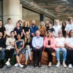
Participants include six surveying students, one cartography student, two Curtin lecturers, four surveying professionals, a two-person documentary team and two Indigenous people.
The Canning Stock Route is a 1960 km remote stretch of track running through the Gibson and Great Sandy Deserts. No longer in use as a stock route it is now a popular 4WD track, allowing access to the wells constructed as stock watering holes.
Note to Editor: A photo session has been organised for Thursday 19 June at 3.00 pm close to the Manning Road entrance of Curtin University. Students and staff will be dressed in expedition gear with appropriate surveying equipment and vehicles. Press photographers welcome to attend, please call Lisa on 0401 103 755.
Further information:
The budget for the trip is $35,000. All funding for the expedition has been sourced through sponsorship from the Surveying and Mining Industry.
Thank you to Sokkia, Associated Instrumentation, Landgate, Reward Minerals, Land Surveyors Licensing Board, HWE, Curtin University Spatial Science Department, Land Surveys, Harley Survey Group, Property People Surveying, McMullen Nolan, Whelans, Fugro, Survey 21, RM Surveys, Cottage and Engineering Surveys, Austin Surveys and Centreline Pty Ltd, for their support and generosity.
Contact: Kirby Gamble, 0427 773 602, Kirby.gamble@student.curtin.edu.au or Lisa Mayer, PR Coordinator, Curtin, 08 9266 1930, 0401 103 755 l.mayer@curtin.edu.au
CRICOS provider code: 00301J
Modified: 19 June 2008